Sarnia presents a tale of two geologies. The industrial waterfront along the St. Clair River, with its legacy fill and buried infrastructure, demands a completely different imaging strategy than the residential subdivisions expanding into the clay plains south of Highway 402. In the river corridor, we often deploy high-resolution reflection profiling to trace buried concrete structures and old sheet pile lines, while the southern developments rely on seismic refraction to map the depth to competent shale bedrock beneath the glaciolacustrine deposits. The contrast is stark, but the common thread is the need for continuous subsurface data—something that a seismic refraction survey provides far more efficiently than a grid of boreholes alone. In a city where the water table sits barely two meters below grade, understanding the velocity structure of the saturated overburden directly informs both excavation design and foundation selection.
A seismic velocity of 1800 m/s in Sarnia's overburden often indicates dense till, not bedrock—misidentifying this contact can double your excavation costs.
Applicable standards
NBCC 2020 (National Building Code of Canada, seismic provisions), CSA A23.3-19 (Design of Concrete Structures, foundation requirements), ASTM D5777-18 (Standard Guide for Using the Seismic Refraction Method), ASTM D7128-18 (Standard Guide for Using the Seismic Reflection Method), MTO LS-219 (Ontario Ministry of Transportation geophysical testing)
Quick answers
What is the typical cost range for a seismic tomography survey in Sarnia?
Seismic tomography projects in the Sarnia area generally range from CA$3,460 to CA$6,220, depending on the survey length, depth of investigation required, and whether you need refraction only or a combination of refraction and reflection. A short refraction line for a single-family lot costs less than a multi-line reflection survey with tomographic processing across a commercial site. We always provide a fixed-price proposal after reviewing the site geometry and project objectives.
How does seismic refraction differ from reflection, and which one do I need for my Sarnia project?
Refraction images the subsurface by tracking critically refracted waves along velocity boundaries, making it ideal for mapping the top of bedrock and the water table within about 30 meters of the surface. Reflection uses near-vertical seismic echoes to image deeper interfaces, similar to sonar. In Sarnia, we recommend refraction for most shallow foundation and excavation projects. Reflection becomes the better choice when you need to see stratigraphy below 30 meters, or when site noise from the Chemical Valley operations masks the weaker refracted arrivals.
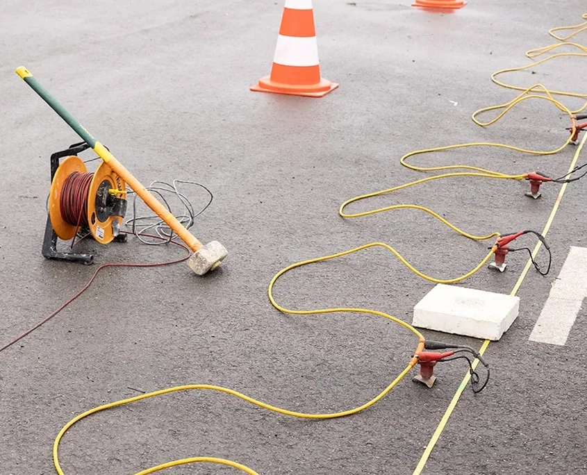
Can seismic tomography work on paved or concrete-covered sites in Sarnia's industrial areas?
Yes, but with modifications. On asphalt or concrete, we cannot plant geophones directly into the ground, so we use base plates coupled to the surface with a viscous couplant or drill small pilot holes through the pavement at each station. The data quality on paved surfaces is generally good for refraction work, though reflection surveys lose some high-frequency content. We have completed multiple surveys inside active refinery and chemical plant sites in the Sarnia area using these adapted techniques.
How long does a seismic tomography survey take, and what access do you need?
A single refraction line of 115 meters typically requires half a day of field work, including setup, data acquisition, and demobilization. Larger grids with multiple intersecting lines can extend to two or three days. We need linear access along the survey line, roughly 2 meters wide, free of heavy vehicle traffic during the active shooting. Post-processing and interpretation add approximately one week, and we deliver the final report with 2D velocity cross-sections and interpreted geological boundaries.